Road Trip, Day 16: Cape Breton's crown jewel and a few other gems in Cheticamp
DAY 16: AT A GLANCE
Starting Point: Meat Cove, Cape Breton Island, Nova Scotia
End Point: Chéticamp, Cape Breton Island, Nova Scotia
Starting mileage: 190,255
Ending mileage: 190,325
Daily total (miles): 70
Trip total (miles): 2030
Day 16 had us leaving Meat Cove Campground and heading down to Chéticamp, where we’d be camping in the van for the evening at Chéticamp Campground within Cape Breton Highlands National Park. On the way, however, we planned to stop and hike the Skyline Trail, probably the most popular trail in all of the park. Our drive on this section of the Cabot Trail was absolutely stunning—so much so that every time we saw a pull off, I made G pull over the van.

A view of the Aspy Fault, created by the shifting of continental plates over the course of millions of years.

The view of the MacKenzie River Valley. The MacKenzie River flows 16km through a canyon to the Gulf of St. Lawrence.
Around every corner, the views just got more and more incredible. As G navigated the van through the winding roads, I kept looking out both the front windshield and the rear window, ogling each view. We toured the Cabot Trail counter-clockwise, starting in Ingonish and ending in Chéticamp, so that we’d always be closest to the side of the water. Lots of folks do it the other way around and, honestly, I’m not sure one is “better” than the other. The views are stunning no matter which direction you’re headed!

We arrived at the Skyline Trail right around 11:30 a.m., and the parking lot was beginning to fill up; we were hoping that the skies would clear a bit (which they did!) and that we’d finish the hike before the clouds rolled back in (which we did!). Haley at MEC in Halifax had told us that with Skyline, you walk quite a bit before the views, and she was right—the trail begins with a walk on a boardwalk and a wide gravel path. There are often moose sightings on the trail, but we didn’t see any.

Then, after about 2 miles of the gentle trail, there’s the payoff: the views. There are several sets of stairs leading further down the Skyline Trail. The views—from the top of the steps, from each landing, from the final platform—are spectacular. We followed the boardwalk all the way to the end and took it all in.
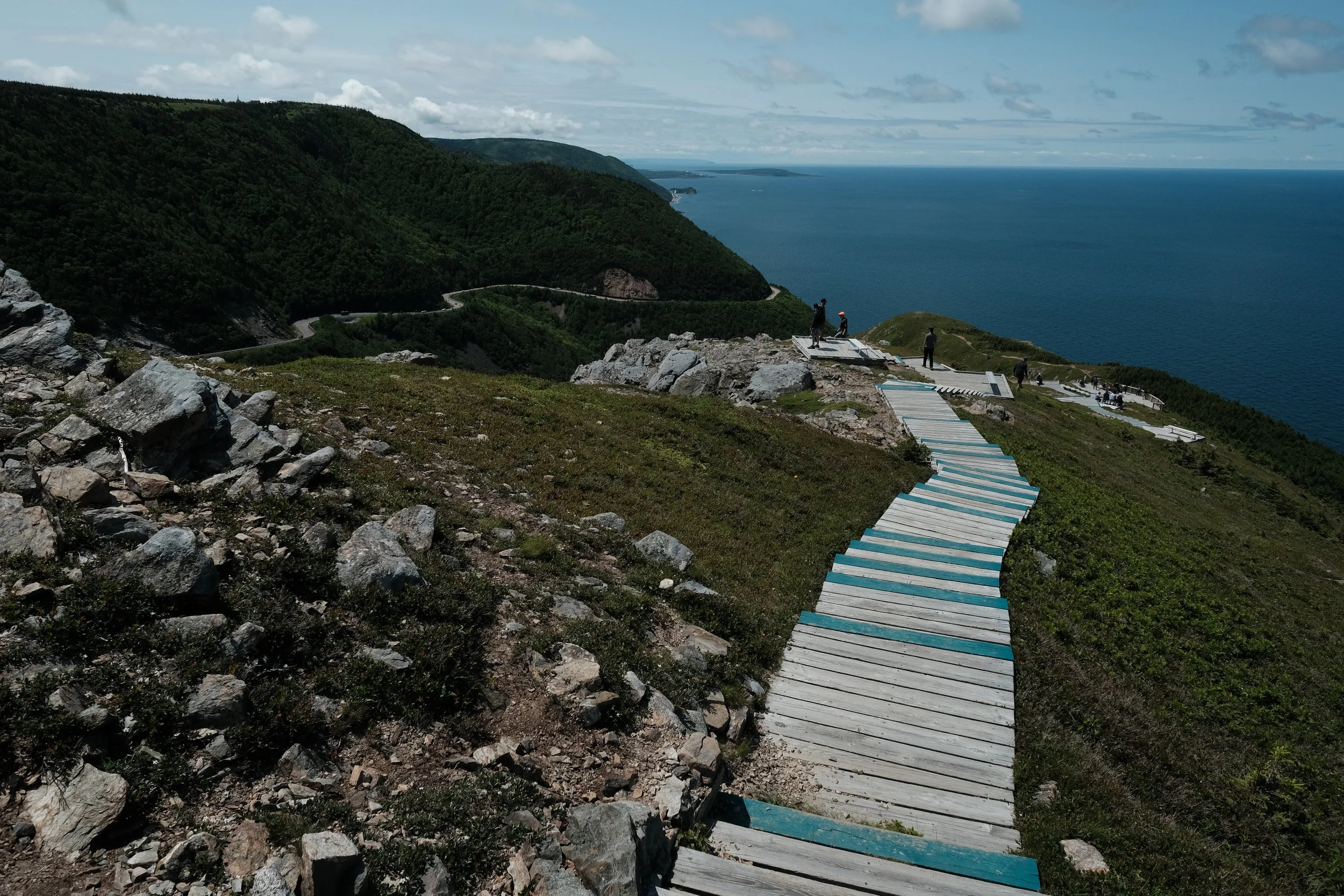


What goes down must go up, so we began our trek back up the steps and out the way we came. There’s a loop portion of the trail, which adds some distance, but it was closed the day we had visited. The entire distance of what we did was 4 miles. The hike is listed as “easy,” and it was, for the most part. Still, four miles and all of the steps might not be considered easy for all ability levels; however, even if one were to stop at the first platform and not continue on down all of the steps, the views would be spectacular—G actually thought they were better the further up he was. I was so bummed that I forgot to use my GoPro to capture the views! Aargh.

G took this pano with his iPhone fro one of the upper platforms on the trail before continuing down the steps.
Before leaving the parking lot, we gave an impromptu tour of the van to a great family from the Truro area (but originally from Yarmouth area) of Nova Scotia. The couple must have been in their 50s with their 20-something daughter, and the father had asked G if we could sleep in the van. G started explaining how the pop-top worked and then offered to show them inside. We all got to chatting, and they gave us some great suggestions for future travels—especially a return so we can attend the Celtic Colours Festival, which sounds incredible!! After our fun conversation, we were off.
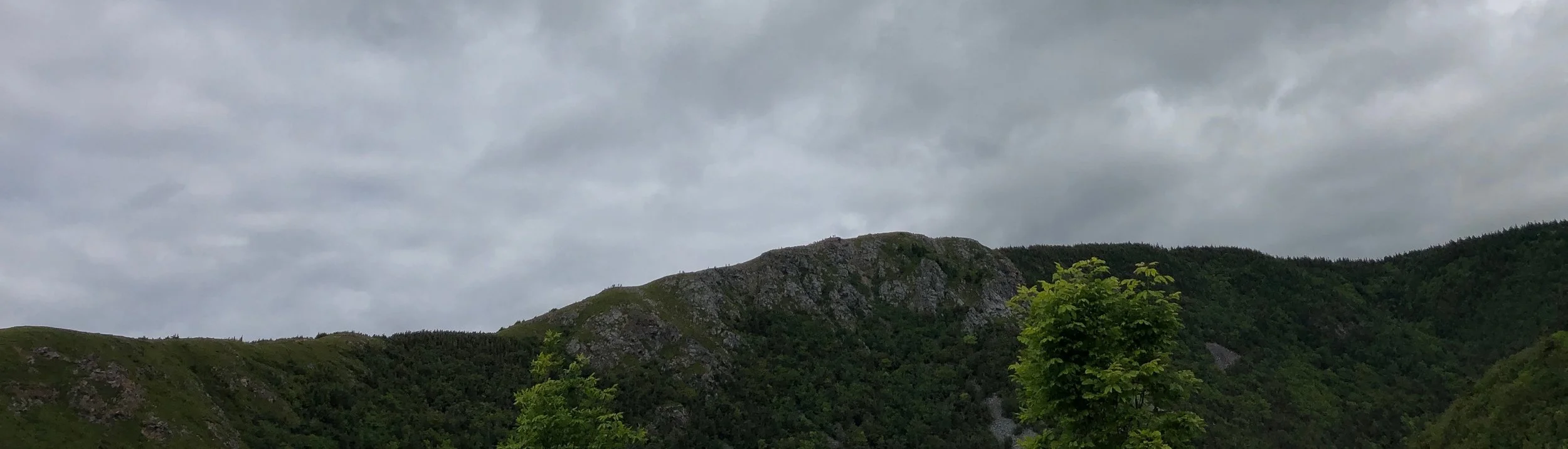
Luckily, the weather had held out for us, as we had fantastic skies at Skyline. By the time we left the parking lot about an hour and half/two hours later, however, the clouds were already rolling in. As we left the trail to make our way to Chéticamp, we were able to look out the window to see the silhouettes of all the people hiking Skyline. All those little “bumps” on the ridge in the photo below: they’re not part of the landscape—they’re people!
We continued to stop at various pull offs to take in the views and a few photos. At one particular pull off, I noticed a plaque that read, “They will never know the beauty of this place, see the seasons change, enjoy nature’s chorus. All we enjoy we owe to them, men and women who lie buried in the earth of foreign lands and in the seven seas. Dedicated to the memory of Canadians who died overseas in the service of their country and so preserved our heritage.” Amen to that.

Once in Chéticamp, we spotted a cute storefront featuring the old-school Cabot Trail highway sign—the same logo we had spotted on stickers at the Wreck Cove General Store, where we picked up a few. We went in the small store, La Brise Stained Glass Studio, which had incredible stained glass work as well as several products featuring the logo (e.g., mugs, stickers, shirts, hats, hoodies). We learned that Paula, the artist, came across the old sign and resurrected the iconic image to now use on various products. Only a few places carry the road sign merchandise, and we were thrilled to learn that she was the woman behind the stickers we had purchased! While we were there, we fell in love with two of her stained glass creations—a small and large waves design—and purchased them. I would have included a photo in the post, but they’re wrapped up carefully for the drive home! Check out her stained glass work—she’s amazing!

While talking with Paula at La Brise, I asked if she had any recommendations for a place to eat. If you read about our previous day in Meat Cove, you remember that the Chowder Hut was closed. So, we really hadn’t eaten a meal since the previous day’s breakfast. Needless to say, we were looking forward to a good meal. Her recommendation was a place called L’abri—and it was awesome! We both ordered the lobster roll with fries (and upgraded to the parmesan truffle fries). We even bought dessert—for me, a chocolate dipped peanut butter ballad for G, blueberry whipped cheesecake. Everything was incredible, and we’d highly recommend a visit if you ever find yourself in Chéticamp, Cape Breton. So worth the stop!

By this point, the formerly blue skies and warm temps had transitioned to cloudy, gray skies and chilly temps. Since we’d be camping tonight, we decided to take our time and visit the laundromat to get one more load of laundry done, which would take us through the end of the trip. With the weather being what it was, the afternoon/evening wasn’t going to be one where we’d want to spend much time outside of the van. After finishing up with laundry, we checked into our site at Chéticamp Campground and hunkered down. G and I both decided to take showers. I’ll be honest: I’ve never showered at a campground, and I tend to just not shower and wait until I’m home. But, boy oh boy, did that hot shower feel wonderful!!!! G and I passed the time with a few rounds of UNO (wilderness edition), and G beat me two games out of three. Damn. A bit later, just as I was getting ready for bed, I returned from the bathroom to see an incredible sky. I grabbed my phone and snapped a few pics—and with that, the end to Day 16 and our last evening in Cape Breton.
