Day 4: Gaspésie in Gray
DAY FOUR: AT A GLANCE
Starting point: Parc National de la Gaspésie, QC, Canada
Ending point: Parc National de la Gaspésie, QC, Canada
Starting mileage: 11,270
Ending mileage: 11,376
Daily total (miles): 106
Trip total (miles): 848
Today, we woke to a cool, gray day, the colors so unlike the deep, lush greens against blue skies we’ve experienced thus far. Nevertheless, we were on our way to explore a different part of Gaspésie, starting first at the Western sector of the park to walk the 1.4k La Rivière-Cascapédia trail, which, according to the trail description, leads to “the source of one of the most important salmon rivers in Gaspésie.”
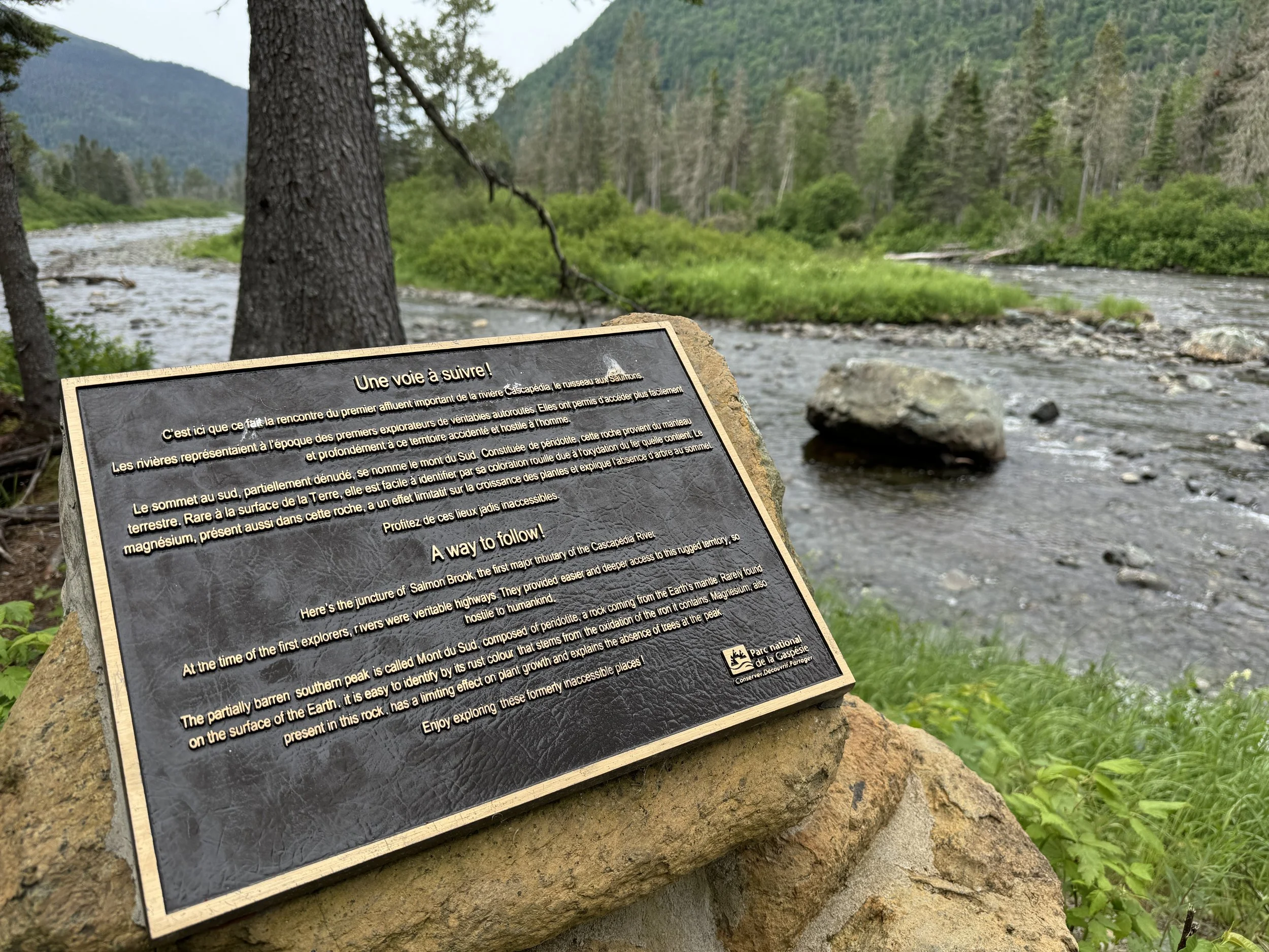
As we got to the end of the trail, there was a plaque with a description (luckily, in both French and English) of our location and its geology.
“Here’s the junction of Salmon Brook, the first major tributary of the Cascapedia River. At the time of the first explorers, rivers were veritable highways. They provided easier and deeper access to this rugged territory, so hostile to humankind. The partially barren southern peak is called Mont du Sud, composed of peridotite a rock coming from the Earth’s mantle. Rarely found on the surface of the Earth, it is easy to identify by its rust coour that stems from the oxidation of the iron it contains. Magnesium, also present in this rock, has a limiting effect on plant growth and explains the absence of trees at the peak. Enjoy exploring these formerly inaccessible places!”
Next up, a stop at the Secteur du Lac-Cascapédia, were pedal boats, motored rowboats, kayaks, canoes, and paddle boards for rent, all making me wish for a second that we had packed our packrafts, as the lake looked calm and inviting (although cold!). We spent a little bit of time at the water’s edge, and I managed to take a few photos I really liked; there’s something to be said for the serenity of the day’s muted colors.


From Lac-Cascapédia, we headed back to the central section, along the dusty dirt roads of the park, so we could walk the 2.6km Le Lac-aux-Américains trail. This trail provided an incredible sensory experience—at times, I found myself simply stopping to inhale the smell of the evergreens lining the trail. Amazing. The view at the trail’s end, however, was even more incredible, as the mountains seemed to cradle the glacial basin. There was a large platform and dock for hikers to sit, rest, photograph, or simply contemplate the view. And what struck us both was the quiet; there were perhaps a dozen (at most) others, yet everyone was silent, as if they, just like the two of us, were taking it all in.


After we had finished the walks and made it back to the cabin, we drove out to the grocery store about 20-30 minutes out from the park, back in Sainte-Anne-des-Monts. Rather than eating at the restaurant again, we had decided to spend the evening in, so we picked up a few salads to have along with the cheese and crackers we bought at the start of the trip. Back at the cabin, we relaxed, played a few rounds of Ticket to Ride (our favorite board game—we have two, just so we can keep one in the van!), and planned for the day ahead, as our mountain journey would be coming to an end in the morning, and we’d be heading back to the coast.