Day 6: Breathtaking Day in Forillon National Park
DAY SIX: AT A GLANCE
Starting point: Parc National de la Gaspésie, QC, Canada
Ending point: Parc national Forillon, QC, Canada
Starting mileage: 11,533*
Ending mileage: 11,572
Daily total (miles): 39*
Trip total (miles): 1,044
*= approximate totals, as I forgot to take a pic of the odometer at the end of Day 5!
Today, Forillon National Park took my breath away—quite literally, as I did a short solo hike up Mont-Saint-Alban and followed that with the hike to a lighthouse at land’s end, Cap-Gaspé. But first, to start the day, another lighthouse just before the entrance to the park (and which you can walk to from inside the park as well), Cap-des-Rosiers.


Cap-des-Rosiers Lighthouse
While the Cap-des-Rosiers site was open on the day we visited, the light itself was closed to the public, so we weren’t able to climb to top—and this one would have been worth it, as it’s the tallest lighthouse in Canada, at 34.1m or 112 feet. The lighthouse is perched at the edge of a cliff, and from there, you can see the vast St. Lawrence across to the far eastern tip of the Gaspé Peninsula. As incredible as the view of the tip looked this morning, it would pale in comparison to the view I’d have in just a few hours…but more on that soon!


After taking a few photographs of the lighthouse and the views, we were off to what was simultaneously one of the things I was looking most forward to on this trip and the one I had the most doubts about: hiking to the observation/lookout tower atop of Mont-Saint-Alban. G, having just finished radiation for prostate cancer a few weeks ago, was definitely not going to be up for the hike, so if I wanted those views, it would be a solo hike or no hike at all. And while I’m an avid walker, I am not a hiker. But I knew (and G reminded me) that I would regret not doing the hike if I chose not to. So, with my backpack carrying two cameras—my Fuji 100V digital camera and my Olympus OM2n 35mm camera—and water, I grabbed my two trekking poles (thank goodness I did!), and I was off for the 5.4km (round-trip) trail to the tower from Grande-Grave. I’m going to write a separate post about the hike and what it meant to me to do it solo, so for now, I’ll just keep it short: it was incredible. Sure, it was definitely challenging for me, but it was also so, so worth it.
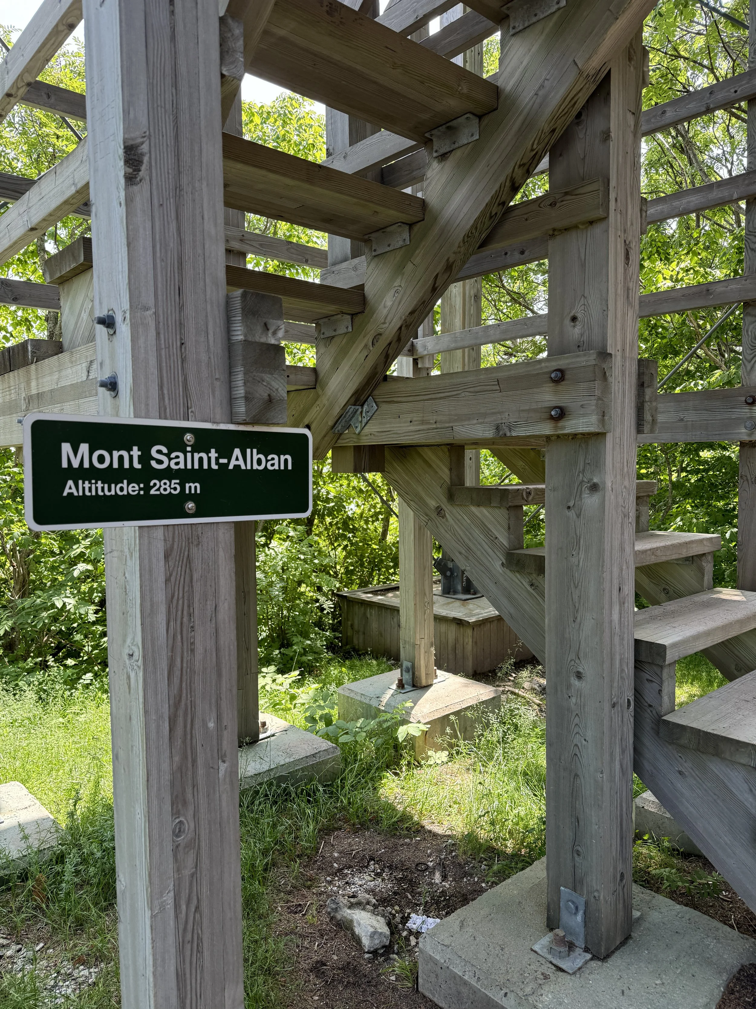
Remember that view from this morning? Well, this is what it looked like from the lookout atop Mont-Saint-Alban (285m/935ft).

And the lighthouse we visited this morning? Cap-des-Rosiers? Yup, it’s that itty-bitty speck at the end of the point in the photo below, also taken from atop the observation tower.

If you look at the end of that tiny spit of land just below the horizon, you’ll see Cap-des-Rosiers. From this vantage point atop Mont-Saint-Alban, the tallest lighthouse in Canada looks like an itty-bitty speck!
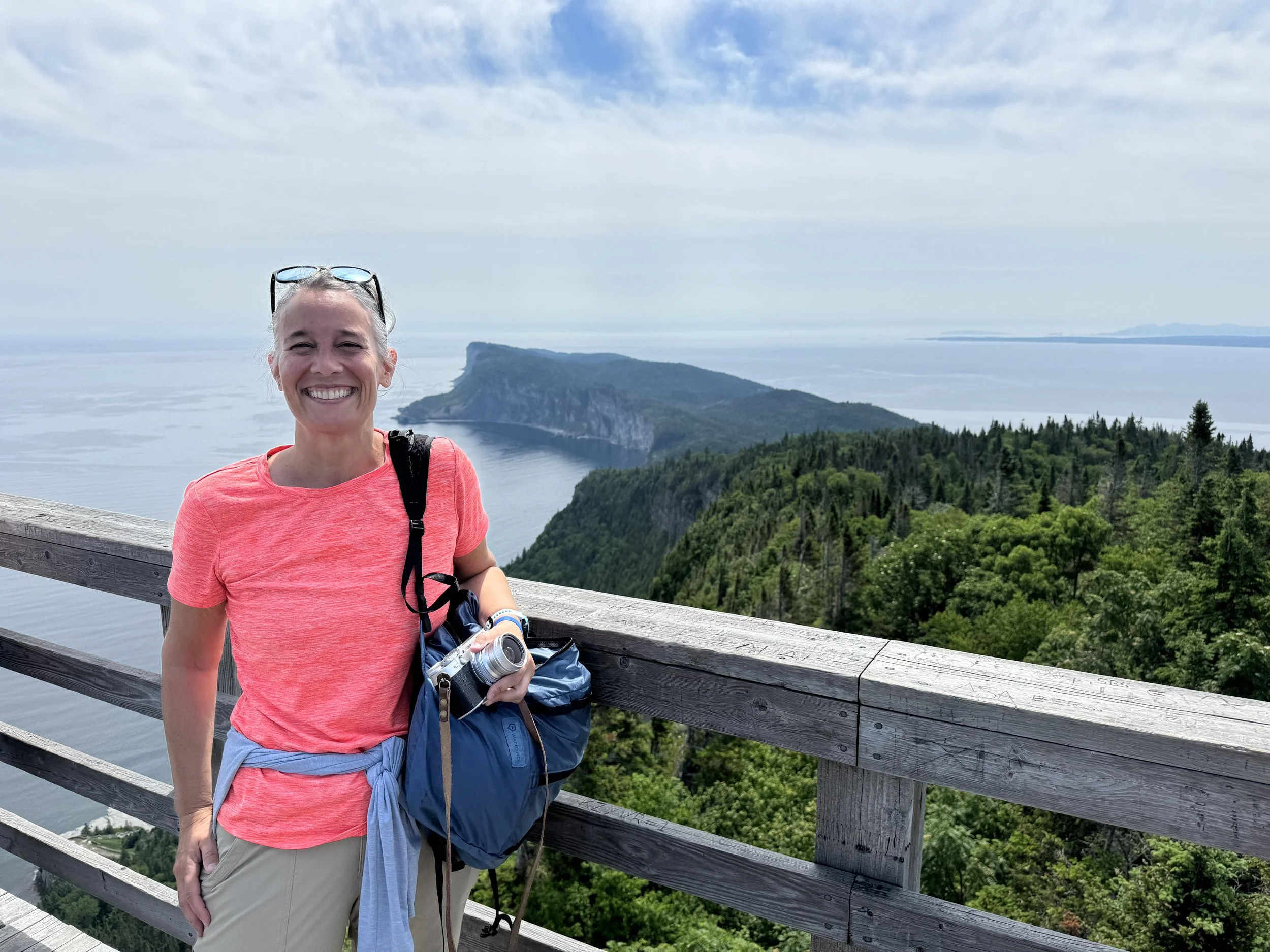
The view from the top of Mont-Saint-Alban really was amazing. I’m sure hikers are rewarded with 360° views all the time—and damn if views like this aren’t reason enough to start adding some elevation to those walks of mine (we’ll see). All I know is that when I took this selfie from the top to send to G, I was absolutely giddy to have made it to the top. And when a nice woman offered to take my photo, I said yes and ignored the fact that I was feeling 1) like an absolute hot mess and 2) still awestruck by the view (and having made it!). Now if you’re reading this and you’re someone who hikes, then this little walk in a park probably seems exactly that: a walk in the park. But for me, it was something much more.


I walked back down the trail—funny how those walks down go soooo much more quickly—and took a bit more photos of the trail so I could eventually remember the trail (instead of just the views!) and be able to write about the hike separately from the day. I met G back at the van (he’s so patient!!), and a few minutes later, we were off for another walk, the Les Graves trail, a 6.4km (4m) hike along a gravel road that would lead to Cap-Gaspé, the lighthouse at the tip of the peninsula. The gravel road parallels the trail of the same name, but with the gravel road being a bit shorter (6.4km vs 8), G opted for that one, and I couldn’t blame him. This would be the longest walk of his up to this point in the trip, and while the elevation gain wasn’t much (60m), the trail was still rated moderate. He wanted to do it, and he figured we’d just take it slow. Given I had just finished my other walk, slow and steady worked for me! And again, the views were absolutely worth it!


After the walk(s), we stopped at the recreation center at that part of the park and grabbed sandwiches and chips for a late lunch/early dinner; once back at the campsite, we’d be ready to crash—hard. And so, we returned to the campsite, and we each took the opportunity to shower in the campground facilities. I don’t typically shower when we camp, but I couldn’t wait to stand under hot water and feel clean after today’s activities. The facilities were incredibly clean, and the water was fantastically hot with great pressure (these things matter!!)—and the showers were free (not coin-operated). The only quirk is the water runs for about 10 seconds at a time, as G had told me when he returned to the van from his. The key, then, was to just keep pressing the button! Finally feeling clean and relaxed, I hung out in the hammock for a bit, while G hung out in the van. By the time we were ready to get the van in sleep mode, G had walked out to retrieve our towels that were outside drying—I could hear him trying to get my attention and telling me to grab my camera, as a caribou* and its kiddo were standing just beyond where my hammock had been! Unfortunately, we didn’t get any photos in time, but wow!!!
*we are guessing caribou and not a moose mainly because of size. Now, keep in mind, neither of us has ever seen a moose, but according to the interwebs, moose are huuuuuge (and these were big, but not crazy big).